
Andrew Hoffman, an incoming professor of Earth, environmental and planetary sciences who will join Rice University’s faculty July 1, was awarded a $1.9 million grant to improve the accuracy, actionability and regional relevance of sea level rise projections. This project (shifting land rising seas) is part of the Gulf Coast Sea Level Variation and Rise Program of the National Academies of Science, Engineering and Medicine, which seeks to better understand the impacts of climate change and sea level across the Gulf Coast region.
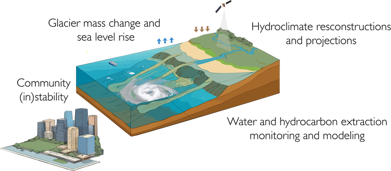
To accurately understand how climate change will impact the Gulf Coast region, models need to consider variables both close and far from Houston. They start, therefore, in the polar regions, looking at past and projected glacier mass change.
“We don’t often associate glacier melt with the subtropical region of the Gulf Coast,” said Avantika Gori, an assistant professor of civil and environmental engineering working on this project. “But glaciers and ice sheets are so large that they have a gravitational pull on the nearby ocean. As they shrink, that pull decreases, and that impact ripples out in very specific ways, which means the resulting sea level rise varies depending on location, rather than a global rise that can be easily predicted.”

Including studying effects associated with the glacier’s pull on the ocean and glacier melt, the team will step closer to home, estimating sediment histories from the river systems that flow into the Gulf Coast, like the Rio Grande, Mississippi and Colorado. This modeling system starts at the source of rivers and incorporates historical information to understand how the sediment impacts what is known as vertical land movement, millimeter level changes in land height that can be measured by GPS and radar satellites. These relatively small changes have big impacts on flood plains, especially when considered over large time scales of a hundred years or more. Understanding them is essential to creating regionally accurate flood maps.
Directly along the Gulf Coast, vertical land movement is also impacted by the aquifers that stretch alongside the coastline. As aquifer water levels rise and fall, from both natural and human activity, so too does the land mass they reside under. Much of the coastal infrastructure from Florida to South Texas is built on top of these reservoirs, and in Texas, these aquifers serve as a major freshwater supply. Hoffman’s team will seek to better map and model changes in vertical land motion due to aquifer changes.
These new vertical land motion models will be combined with climate models that simulate sea level change associated with changes in surface pressure and used to create a more accurate prediction of sea level rise and its impact on the Houston area. But vertical land motion and glacier melts only tell part of the story.
Drawing on Rice’s strong community of social scientists, the team will use data from major Houston-area floods over the past 20 years to understand how sea level rise maps spatially onto indices of community vulnerability. Together with the projections of vertical land movement and sea level rise, this will support better planning for a more resilient future in the face of rising sea level and climate change.
“Being able to transition to Rice with a project that will directly support the greater Houston communities is incredibly exciting,” Hoffman said. “Using a multifaceted lens, we’ll be able to build models that truly help to increase resiliency and improve flood and sea level responses across the Gulf Coast.”