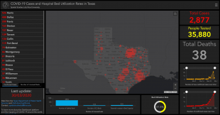
A team of researchers in the Center for Research Computing’s Spatial Studies Lab at Rice University has created an interactive map showing all cases of COVID-19 across Texas utilizing public health data. The map is now online at coronavirusintexas.org.
The dashboard includes cases by county as well as the number of people tested across the state, current hospital bed utilization rate and the numbers of staffed beds and intensive care beds in Texas hospitals. It updates automatically on a daily basis.
Led by Farès el-Dahdah, director of Rice’s Humanities Research Center, the team of geographic information system (GIS) specialists also created interactive maps of COVID-19 cases for Brazil and Lebanon. The dashboard of Brazilian cases quickly went viral in that country.
The dashboards were created using open source code made available by ESRI, a GIS software company, and employ public health data. The interactive map of Texas COVID-19 uses data from the Texas Department of State Health Services and Definitive Healthcare.
“Now that the Texas Division of Emergency Management released its own GIS hub, our dashboard will move away from duplicating information in order to correlate other numbers such as those of available beds and the potential for increasing the number of beds in relation to the location of available COVID providers,” el-Dahdah said.
“We're now adding another layer, which is the number of available nurses,” el-Dahdah said. “Because if this explodes, as a doctor friend recently told me, we could be running out of nurses before running out of beds.”


