Cutting-edge tech comes to new Rice lab on heels of Science study
Undersea telecommunications cables that connect the continents may help measure earthquakes and detect other seismic events, according to a newly published paper based on research conducted by a Rice University professor and his colleagues.
But proof that the technique works might not have happened without some arduous ditch-digging.
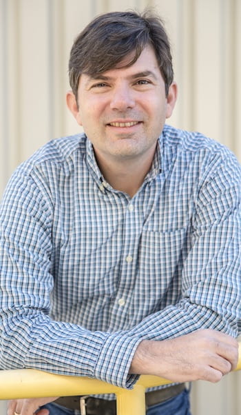
Jonathan Ajo-Franklin
Scientists led by University of California, Berkeley, graduate student Nate Lindsey and Rice geophysicist Jonathan Ajo-Franklin confirmed that telecommunication cables may be useful to collect seismic readings from the seafloor and at great distances.
Their high-profile paper in this week’s Science serves as a nice homecoming for Ajo-Franklin, a 1998 Rice alumnus (Brown College) who rejoined the university this summer as a professor of Earth, environmental and planetary sciences. (A separate article in the issue further describes the research.)
Ajo-Franklin comes to Rice from his position as a staff scientist at Lawrence Berkeley National Laboratory (LBNL), where he and Lindsey, a National Science Foundation graduate research fellow, led an experiment that turned 20 kilometers of fiber-optic cable into the equivalent of 10,000 seismic stations along the ocean floor. The fiber was made available by the Monterey Bay Aquarium Research Institute (MBARI) and co-author Craig Dawe.
During a four-day experiment in Monterey Bay, they recorded a 3.5 magnitude quake and seismic scattering from underwater fault zones using a technique called distributed acoustic sensing (DAS).
DAS employs a photonic device that sends short pulses of laser light down the cable and detects backscattering created by strain in the cable caused by stretching. With interferometry, used to decode interference between the returning signals, they measured the strain signals every 2 meters (6 feet), effectively turning a 20-kilometer cable into 10,000 individual motion sensors.
Researchers had previously confirmed DAS with land-based “dark” fibers, optical fibers buried underground but unused or leased for short-term use, unlike “lit” internet fibers. The latest advance could significantly advance scientists’ reach.
The technique was inspired by a study that led Ajo-Franklin and Lindsey to Fairbanks, Alaska, five years ago. “It involved laying fibers and using ambient noise to detect zones of permafrost thaw in the Arctic,” Ajo-Franklin said. “It was a backbreaking effort to get the fibers in the ground.
“I remember we had a long conversation; like, ‘We know there are fibers in the ground already for telecom,’” he said. “We thought, ‘What if we use those instead of digging these kilometer-long trenches?’ That was the genesis of the idea.”
Ajo-Franklin said the new study is “on the frontier of seismology, the first time anyone has used offshore fiber-optic cables for looking at these types of oceanographic signals or for imaging fault structures. One of the blank spots in the seismographic network worldwide is in the oceans.”
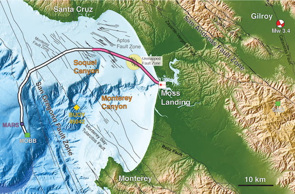
Researchers piggybacked on a fiber-optic telecommunications cable to sense seismic activity in Monterey Bay, turning 20 kilometers of cable (pink) into the equivalent of 10,000 seismic stations along the ocean floor. The cable is normally used to communicate with an off-shore science node (the Monterey Accelerated Research System, or MARS). During a four-day test, scientists detected a magnitude 3.5 earthquake 45 kilometers away in Gilroy, California, and mapped previously uncharted fault zones (yellow circle). Illustration by Nate Lindsey
The ultimate goal, he said, is to use the dense fiber-optic networks around the world — probably more than 10 million kilometers in all, on both land and under the sea — as sensitive measures of Earth’s movement, allowing earthquake monitoring in regions that don’t have expensive ground stations like those that dot much of earthquake-prone California and the Pacific Coast.
“The existing seismic network tends to have high-precision instruments, but is relatively sparse, whereas this gives you access to a much denser array,” Ajo-Franklin said. “These systems are sensitive to changes of nanometers to hundreds of picometers for every meter of length. That is a one-part-in-a-billion change.”
“The beauty of fiber-optic seismology is that you can use existing telecommunications cables without having to put out 10,000 seismometers,” Lindsey said. “You just walk out to the site and connect the instrument to the end of the fiber.”
During the underwater test, according to a University of California, Berkeley, press release, the technique allowed the researchers to measure a broad range of frequencies of seismic waves from a magnitude 3.4 earthquake that occurred 45 kilometers inland near Gilroy, California, and map multiple known and previously unmapped submarine fault zones, part of the San Gregorio Fault system. They also were able to detect steady-state ocean waves — so-called ocean microseisms — as well as storm waves, all of which matched buoy and land seismic measurements.
Ajo-Franklin plans to next test fiber-optic monitoring of seismic events in a geothermal area south of Southern California’s Salton Sea. This work, partnering with LBNL where Ajo-Franklin remains a faculty scientist, will also evaluate temperature profiling using the same network.
“We’re going to do seismic imaging over an active geothermal zone there to see if we can identify the faults that provide fluids to deep reservoirs,” he said. “It’s a dark fiber project where we’re planning to utilize fiber owned by a telecom company.”
Some of that work will come to his new lab, Ajo-Franklin said. “We just purchased a DAS box for Rice and will have a facility to test cables and try different installations and special environments,” he said. “And we’ll use this technology in field deployments around the world in places that are seismically interesting or have structural imaging targets.”
Though southeast Texas lacks the seismic activity that characterizes regions around fault zones, Ajo-Franklin plans to take full advantage of benefits he sees in the local environment.
“If you’re interested in ambient noise imaging, this is actually a good place to be,” he said. “We work a lot on what’s called ambient noise seismology, using all the random noises propagating through the Earth. If you do a bit of signal processing, you get something that looks like an active-source seismic section.”
He said DAS could be used to measure the effects of hydraulic fracturing for oil production, as well as wave action in the Gulf of Mexico and local hydrogeologic processes.
The research was funded by the U.S. Department of Energy, the National Science Foundation, and the David and Lucile Packard Foundation.

