Rice University professor leads active seismology component of NSF-funded study
Rice University Professor Alan Levander and a crew of researchers are preparing to perform what amounts to an ultrasound examination of Mount St. Helens in a project funded by the National Science Foundation (NSF).
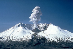
The dramatic eruption of Mount St. Helens in Washington killed 57 people in 1980.
The four-year effort will likely begin operations at the active volcano in Washington next summer, when Levander and his colleagues place approximately 2,500 active and passive seismographs around the mountain. To gather data with unprecedented resolution about the mountain’s structure via the active seismographs, they will set off a series of “shots,” controlled explosions in wells drilled to a depth of about 80 feet at many points around Mount St. Helens.
That process will take three to four weeks, said Levander, Rice’s Carey Croneis Professor of Earth Science. From that data and more gathered from the passive seismographs on the mountain for two years, they expect to gain a clear picture of Mount St. Helens’ plumbing and more refined knowledge about the volcano’s behavior before an eruption — the better to warn its neighbors.
“The region from Seattle and Vancouver to the north, to Portland, south, is becoming a megacity much like the Los Angeles area and the Northeast Corridor,” Levander said. “The volcano spews out very abrasive silicon that settles as a dust and wrecks mechanical equipment. It’s also bad for human lungs. In 1980, the prevailing wind was off the water and blew it inland away from populations centers, but if the wind blew north or south, it would have been a much bigger problem.”

The new National Science Foundation-sponsored study will give researchers a set of high-resolution data detailing the topology inside and underneath Mount St. Helens. Courtesy Alan Levander/Rice University
Mount St. Helens is ideal for the study for many reasons, not the least of which is its well-documented recent history, Levander said. In 1980, the mountain erupted after two months of earthquakes and other warnings and deposited ash in 11 states. The blast killed 57 people, but warnings by the United States Geological Survey (USGS) saved thousands of lives.
Levander is principal investigator on the active source component of the project. Other institutions involved include the University of Washington, Oregon State University, Lamont-Doherty Earth Observatory, Eidgenössische Technische Hochschule of Zurich and the USGS. Overseeing the project are EarthScope, the NSF-funded project responsible for the USArray, and the Cascadia Initiative of GeoPrisms, chaired by Julia Morgan, a Rice professor of Earth science.
Levander said other mountains in the Cascade Range, part of the Pacific Ring of Fire, were considered. “Mount St. Helens is unusual among the Cascades because it’s in front of almost all of the rest of the volcanoes,” he said. “The slab under the mountain is only about 80 kilometers deep, and that’s unusual; the average depth is 105 kilometers.

Alan Levander
“Geologists at the University of Washington in Seattle have a long interest in the Cascades, which present a danger to them,” Levander said. “They wanted us to do Mount Rainier, but Rainier is a beast of a volcano – and it’s a national park, which makes working there very difficult. I think we would have a very hard time seeing into it.
“But Mount St. Helens is smaller and easier to access,” he said. “We know it’s active, and it’s a major threat. And to our advantage, after the eruption, the mountain was set up as a national monument for scientific research. So the people who run the monument are interested in our work; we just have to be careful not to interfere with their biology experiments.”
The Cascades sit atop a subduction zone, where one tectonic plate moves under another. “Minerals get hydrated sitting on the seafloor, so there’s a huge amount of water bound up in the oceanic crust and the upper mantle,” Levander said. “As the oceanic plate descends, it heats up. The combination of the pressure and increasing temperature releases that water, which goes into the mantle under the crust. The water reduces the melting temperature in what’s called the mantle wedge – the flowing mantle between the subducting slab and the bottom of the crust.
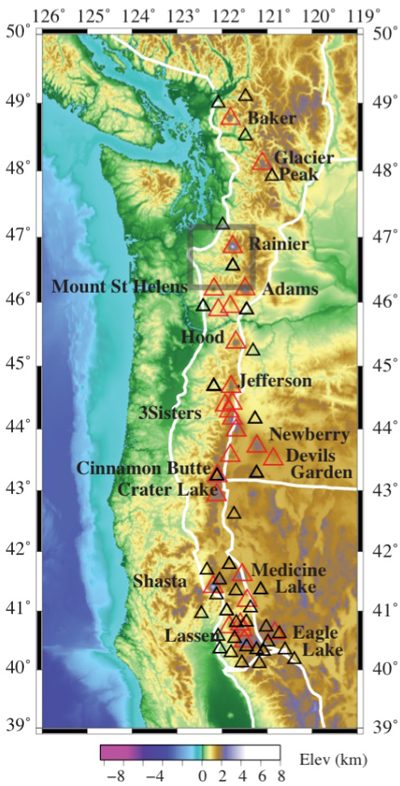
Mount St. Helens is the western-most volcano in the Cascade Range. Courtesy Alan Levander/Rice University
“The melting mantle wedge produces volcanoes – but does it in a very complicated way,” he said. “The melt is enriched in silica while rising into the lower crust, and then ponds in a magma chamber and ultimately erupts. Because it carries volatile elements like water and carbon dioxide that build up, these eruptions can be explosive.”
As Mount St. Helens is on the leading western edge of the Cascades, the work should provide a wealth of information about the entire region, Levander said. Ultimately, he expects NSF will spend about $3 million on the project, with more than $1 million for his active source work.
“We expect we’ll have a clear picture of all the processes, from where the slab dewaters all the way up to the upper magma chamber, where the magma gets pressurized and causes either an eruption or a flow,” he said.
The multiscale data will be used to build three-dimensional images for display on the likes of Rice’s new DAVinCI Visualization Wall, also funded by NSF and expected to go online soon. There, researchers will be able to walk through the depths of a virtual Mount St. Helens and study it in detail.
The work will not be Levander’s first encounter with the mountain. “I actually saw one of the eruptions in 1980 when I was in graduate school,” he said. “Not the big one in May, but a secondary eruption in July. I was in operating equipment in the back of a truck parked on a bluff outside Bend, Ore., working the summer for an oil company; I looked up, and there was a big eruption on the horizon. I could see the plume. For an Earth scientist, it was pretty cool.”


Leave a Reply